


This post covers Part Two of our week-long road trip through Western Australia, spanning days 3, 4 and 5, where we drive from the logging town of Pemberton to Cape Leeuwin, then up Caves Road to Margaret River, and finishing halfway through Day Five with our drive to Fremantle with a few stops at beach towns along the way. Part One, Perth to Walpole and Pemberton, can be found here.
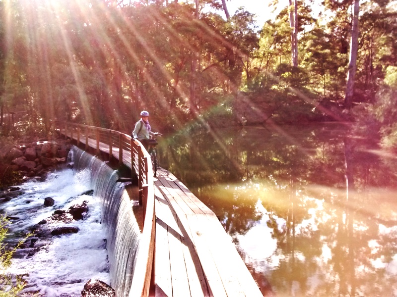
Still full from our huge dinners in Pemberton the night before, Sam and I skipped breakfast on Day Three of our road trip, hopped into our car and headed east toward Cape Leeuwin, the most south-westerly point on mainland Australia. The drive to the Cape Leeuwin Lighthouse took about two hours, with scenery along the way, especially the drive along the rugged coast from the town of Leeuwin to the lighthouse.
Cape Leeuwin Lighthouse Tour
The Cape Leeuwin Lighthouse was another destination we decided upon on a whim, and I’m so glad we did. Not only is it Australia’s tallest mainland lighthouse, but it also overlooks where the Indian and Southern Oceans meet. Quite serendipitously, I realized upon visiting that we were at the site where a novel I recently finished, The Light Between Oceans, was loosely based (the story is set on a fictional island between these two oceans). When I asked our tour guide if he was aware of this, he said the author actually came here to conduct research for her novel a few years ago!


Finally, we learned during the friendly lighthouse tour ($20 AUD per adult) that the view from the top has been voted third best ocean view in the world … not sure by whom exactly, but upon seeing it for ourselves, we have to agree it is stunning. Pictures don’t do this place justice, because it is the experience that really makes an impression. Turning to face the sea from the platform just below the lighthouse lens, the wind whips at your face and far below, the Indian Ocean churns into the Southern. It is untamed and vast, and standing there with the sky lashing all around and the sea roaring below, you feel in the presence of pure energy. Then, walking to the other side of the platform, directly 180 degrees, the wind suddenly calms and far below, the landscape spreads green and peaceful between two shores. So, in just one turn around the lighthouse lens, you’ll find a world of wild unknowns while on the other, a tamed, pastoral scene. It felt profound.

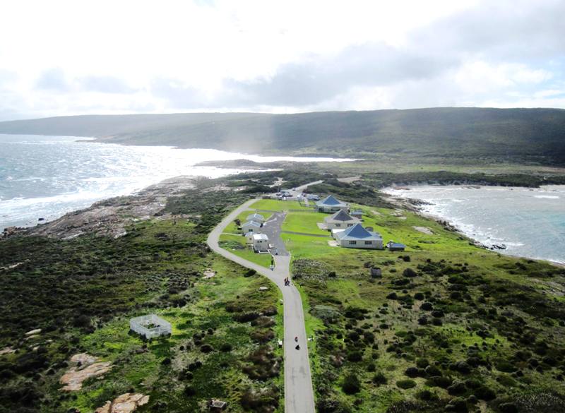
Our tour finished, our guide suggested we visit the water wheel site — where fresh water was once supplied to the lighthouse community –, just outside the parking area of the lighthouse to the left (if facing away from the lighthouse). We didn’t even notice this coming in as the water wheel is tucked along a gorgeous, rugged beach that you can not see if you don’t stop and walk down to it. What’s left of the structure is quite interesting, and the rugged, natural surroundings help provide some feel of what it must have been like to live here, all alone but for the few people in the lighthouse community.


Caves Road to Margaret River
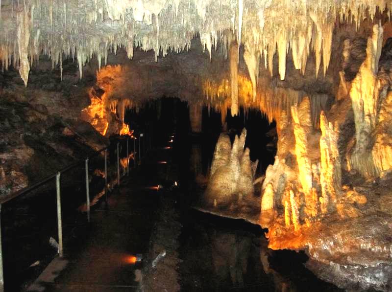
Heading north from Cape Leeuwin, we followed Caves Road (which was described as “scenic,” but for the most part, unless you venture off Caves Road and follow the little streets snaking toward the coast, all we saw were trees, to be honest). We stopped at one of the many caves along Caves Road: Lake Cave, because it … well, has a lake. That’s something we’d never seen in a cave before!
The tour was interesting; it starts with a well landscaped but significant descent into the earth, so that, as you follow the stairs and walkways winding down, you suddenly find yourself surrounded by cliffs where trees tip perilously from sunny edges. Once inside this sinkhole of sorts, a narrow stairway declines through a rocky portal into the cave itself.


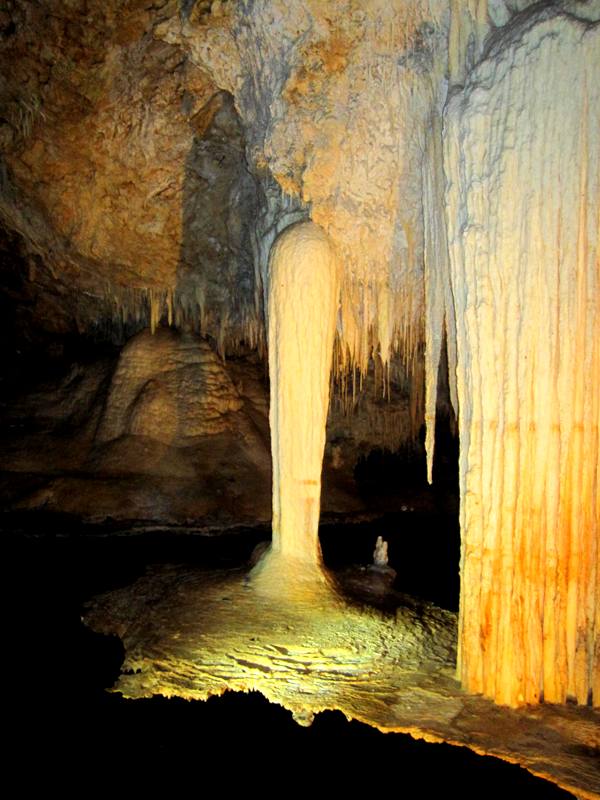
Once inside, a metal walkway hovers over the [extremely] shallow lake while all around, delicate stalactite straws, trippy stalactite columns and curtains, and even a stalactite table — which I believe is supposed to be the largest ever discovered — glow golden under the lights.

We really enjoyed our stop at Lake Cave, but one cave was enough for the day, so we headed a bit further north, then east to the cute, touristy wine-region town of Margaret River. We arrived mid-late afternoon, so we had plenty of time to find a room and walk around town a bit. This is the place to shop for nick-knacks if you haven’t had a chance to before, as every other shop seems to cater to tourists, though it is clearly a residential town as well. The Visitors Center provides all kinds of information on wine tours, activities, rooms, you name it. There are vineyards weaving in all directions from Margaret River, so even if you don’t have a map, you’ll be sure to stumble across a few anyway! We picked up a few maps for self-bicycle tours (one is below) and booked a room for two nights at The Grange — a lower to mid-range hotel (motel) within walking distance to town. If we were to do it again, I think we’d stay somewhere else next time — mostly due to housekeeping issues — but the manager was quite nice and eager to help resolve certain problems. Also? I think the price would have been better if we’d booked through online channels such as Trip Advisor rather than the Visitor’s Center, but the staff at the VC were so helpful and kind, we’re glad if we supported their operation in some way.
For detailed, downloadable maps of Margaret River and the surrounding area covering Cape Leeuwin from the south to Cape Naturaliste to the north, check out www.MargaretRiver.com.
Day Four: Touring Margaret River’s Trails
The next day, we rented bikes from the friendly Margaret River Cycles & Repairs (08-9758-7671; info@westozbikes.com) and headed out for a day of exploring the many mixed-use trails in the Margaret River region. While the below map is helpful, there are so many trails — single tracks, mostly — curling off in every direction once you get into the woods, particularly off the Rail-Trail ride to Cowaramup. If you can, bring or rent a mountain bike because those trails looked like a lot of fun! We didn’t rent mountain bikes — mostly because we didn’t know about the single tracks.

A word of advice on bicycling the Margaret River trails: if you rent bikes with the intention of doing anything more than riding about town, for the love of all that’s holy, do NOT choose the cute, beach-cruiser-meets-roadster looking bikes that beckon you with cheery colors and Hey-Look-I’m-Riding-In-Amsterdam nostalgia. We learned the hard way that, though these newly built bikes do resemble Dutch or English Roadster cycles in appearance, the geometry is quite different as the seat sits much further back, pedals are lower to the ground, and the wheels are only 26 inch-ers rather than 28-inch or more. Great for holidaymakers tooling about town who might be nervous about cycling so want their feet close to the ground, but frustrating, inefficient and downright tortuous if cycling longer distances with any kind of incline. Don’t do it, my friend. I know what I’m talking about, because … we did.
Other than that, we had a great time riding from Margaret River to Prevelly Beach and back, then tackling the rail-trail to Cowaramup that afternoon. The paved trail to Surfers Point at Prevelly Beach was a pretty ride and well maintained, and along the way, we passed what we think must be Kangaroo farms (do these exist?!) as the Roos were definitely within fenced enclosures like cattle, just kind of hanging out. From a distance, they actually looked a lot like deer to us, as the shape of their heads and slope of their back are similar when sitting.


The rail-trail ride to Cowaramup wasn’t quite as scenic as most of it is going through the woods. Also, I think our moods were a bit dampened by our bicycle choice. It isn’t that the trail was difficult — it wasn’t at all — but there is a gradual incline pretty much the whole way to Cawaramup, and on those townie bikes with tiny wheels and weird geometry, it really took its toll after a while. Also, as mentioned earlier, there were all kinds of single tracks zipping off here and there that would have been great fun to explore on a mountain bike. I think the most scenic part of the ride was when we had to find a side route over a river (below) because the rail-trail bridge was closed for construction.

Day Five: Margaret River to Fremantle, via Caves Road
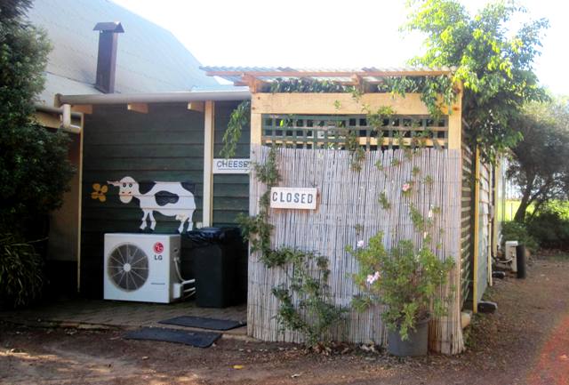
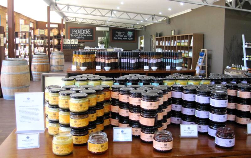
The drive from Margaret River to Cape Naturaliste, along Caves Road, winds through verdant farms and wineries and an assortment of micro-gastronomic endeavors. One could easily spend a few days sampling the various wines on offer, but since we were on a road trip instead of a tour, we chose to sample food items instead … and buy the wine for later! We stopped at the tiny Margaret River Cheese Company (they opened right after this photo was taken) and then at Coward & Black’s winery-chocolate factory-culinary conglomerate that, according to which building you enter, has a corresponding name. Almost everywhere offers up free samples of their goodies with the hope of securing your purchase. We bought a spreadable cheese, then some chocolates (so-so to be honest) and then an olive-paste spread at Coward & Black’s Providore shop, which has all sorts of vinegar, oils, spreads, spices and dessert liquors to sample.


The drive north from Margaret River to Cape Naturliste takes under an hour, but it took us a bit longer due to our sampling stops. Cape Naturaliste marks the other end of the 140-kilometer Cape to Cape Walk (Cape Naturaliste to Cape Leeuwin), and offers several hour-long walks along the rugged coastline as well.

We just stopped for a photo of the lighthouse, then headed east to the cute, artsy/touristy town of Dunsborough for lunch. We discovered that those cute, artsy/touristy cafes had prices to match, however, so we bought a couple of rolls and coffee from the awesomely fresh and inexpensive Dunsborough Bakery and made a picnic with our spreadable cheese and olive paste instead, then stopped at the town of Busselton to take in their jetty, which at nearly two kilometers, claims to be the longest wooden jetty in the Southern hemisphere! We parked at the extremely well-kept ocean-front public park within walking distance of the jetty, with many picnicking spots and the cleanest restrooms I think I’ve ever seen in a public area. Once at the jetty, several tours are offered from the Interpretive Center there — including a tram ride down the jetty and a some kind of underwater glass room where one can visit the marine life hanging about — but we just walked around a bit and then headed for our day’s final destination: Fremantle.

So that’s Part Two of our seven day road trip through Western Australia. Coming up: Days Six and Seven in Fremantle and Perth, including an amazing drive to Pinnacles Desert with a stop to sand surf at the Lancelin sand dunes!
Hi Jesse.
I just wanted to add a comment regarding the bikes you mention in this article. If I recall correctly, the brand of bikes we rode was Electra. They have a frame geometry in which the seat sits further back relative to the peddles. As a result, the seat can be closer to the ground, while still far enough from the bottom bracket (the part where the right and left peddle are connected to one another in the bottom of the bicycle frame) to allow the rider to peddle normally. These bikes are designed for novices (or perhaps the inebriated) so that as you mentioned, the feet can be firmly planted on the ground while still sitting in the saddle.
I had previously read about these bikes several years ago and was actually curious to try them out. I am no longer remotely curious to ever try them again. As you mentioned, they are fine for simply tooling around town a bit, but for the love of all that is holy, I strongly advise anyone thinking of riding one of these geometrical abominations to travel anything more than a mile or two, especially with any sort of an incline, to stop what they are doing and choose a different bike. The ride to Cowaramup (which I can’t help but to pronounce as “Cow Rump”), should have been fun and easy. On these bikes, whose frame geometry was clearly designed by the Marquis de Sade, it was like descending into Dante’s nine circles of hell.